-
"The world doesnt make sense, why shoud I paint pictures that do?"
- Pablo Picasso
Identifying Potential Isolated Communities and Facility Allocation - Disaster Response
Client: FEMA Regional Geospatial Office’
Year: 2020
Audience: Emergency management that needs to understand the variables contributing to a community's risk of isolation is a crucial aspect of disaster preparedness and response. Incorporating these factors in real-time to identify potentially isolated communities is vital for effective intervention and support.
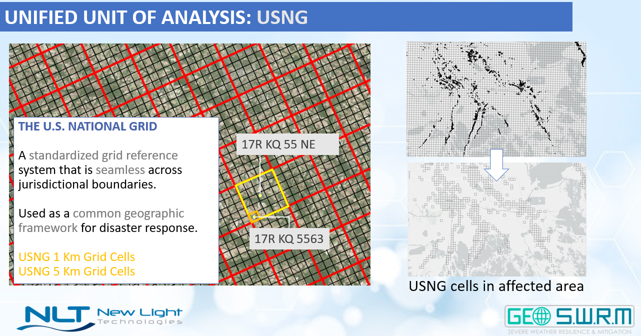
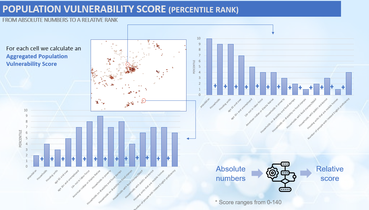
Role: The research project implemented cost distance allocation and measured changes in travel time through the closest facility network analysis. Combined with network analysis and social vulnerability data, this approach creates an isolated risk index that offers a real-time prediction of areas at risk of isolation. The results are presented at the USNG grid level, providing a geographic understanding of regions particularly susceptible to isolation during specific events. This solution enhances the ability to proactively address and manage the challenges posed by community isolation in emergencies.
TEMPO - Tool for Emergency Management and Prioritization Operations
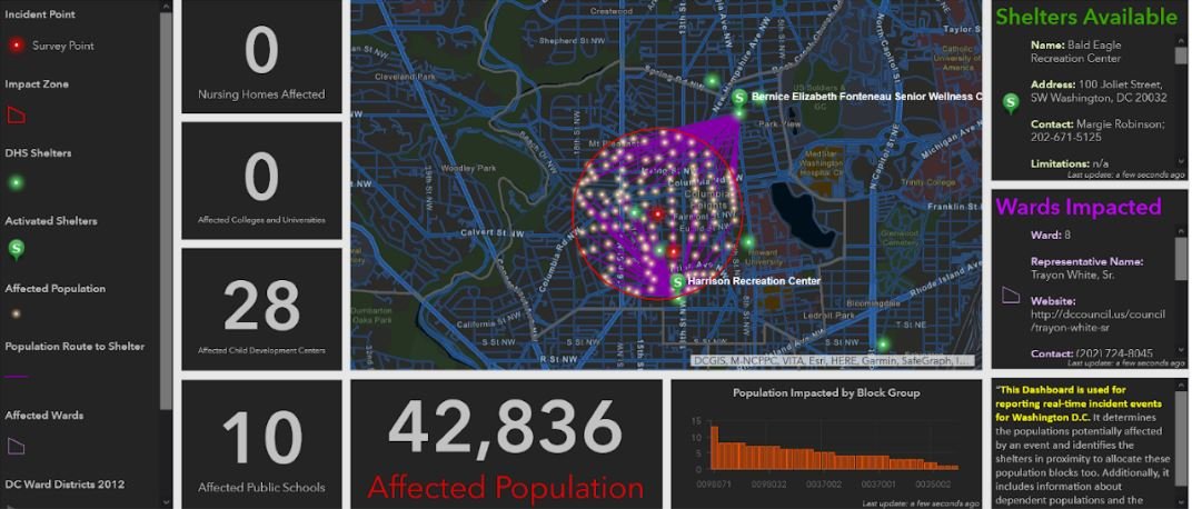
Client: FEMA Regional Geospatial Office in Washington, DC.
Year: 2022
Audience: Emergency management teams that must assess locations at the highest risk of disaster situations in real-time based on social vulnerability, structure type, operational status, and hazard intensity. A system that provides alerts and monitoring. The TEMPO architecture uses AI/ML algorithms to continuously analyze live data throughout an incident's lifecycle, identifying vulnerable areas and lifelines with cascading effects.
Role: Identified the best accessible real-time data sources and built pipelines from API to database for model ingest for critical infrastructure. Responsible for training and operating the model during hurricane season.


Landslide Risk Assesment - Post Wildfire Scenario
North Carolina State MGIST Program
Year: 2020
Audience: Landslides damage infrastructure and endanger life. Landslide susceptibility mapping is essential to detect risky locations (Growley et al., 2008). Post-wildfire recovery research and landslide susceptibility maps help mitigate hazards, plan regionally, and prioritize recovery operations.
Solution: I created a Landslide Risk Index Product to identify terrain surfaces prone to debris flow landslides after wildfires. This investigation focused on the November 2018 Camp Fire in Butte County, CA. Worked with many datasets to determine landslide risk. I included SURRGO soil data, NBR Index, NDVI change detection products from Sentinel 2, and Digital Elevation Model slope and aspect data in a spatially weighted overlay. Additionally, USDA hydrological datasets were used. Each topographical characteristic was retrieved using several geospatial approaches, turned into raster products, and then categorized on a 1–5 scale, with five indicating the highest landslide risk and one the lowest.
Audience: The landslide risk index identified high-risk developed regions and key infrastructure. I used visuals and charts to reveal landslide-prone locations and improve decision-making and risk mitigation.


Dubai Shoreline Geomorphology and Curation of Coastline Vulnerability Index - UAE
Client: Radar Solutions and College of Engineering and IT, Dubai
Year: 2017
Project: Global climate change predictions predicted a 42–98 cm rise in sea levels by 2100. This study examined how the UAE coast, including tourist destinations, ports, hotels, and residential complexes, will be affected by eustatic sea-level rise. The examination used advanced geospatial technologies to assess coastal geomorphology, slope, land use/land cover, shoreline changes, mean spring tide, and significant wave height. The coastal vulnerability index classified shorelines as very high-risk, high, moderate, and low. In particular, 13.8% of the UAE coast was highly high-risk, stressing the necessity for mitigating actions. This extensive research helped planners and authorities develop adaptive coastal structures to manage rising sea levels and storm surges.
Role: As a remote sensing analyst, I used imagery to detect coastline geomorphic features and assign risk levels for the Coastal Vulnerability Index.


TEMPO: The Tool for Emergency Management Prioritization & Operations

Role: Research hazard, demographic, and critical infrastructure datasets that are most viable for the model. Design tempo models to monitor exposure based on essential impacts of infrastructure. Automate and update models with Python notebooks. Set up the project in GitHub for the team to utilize.
Project: (TEMPO) leverages a scalable AWS cloud-native microservices architecture to ingest the best available data detailing the location and intensity of hazards, population, infrastructure, and other community information. It then applies AI/ML algorithms to continuously analyze live data throughout an incident lifecycle to determine community areas and lifelines of the highest vulnerability, impact, and cascading effects.
Client
New Light Technologies Product
Year
2018 - 2022
POST - Prioritizing Operations Support Tool
-
![]()
Collection Priorities
-
![]()
Granular and Uniform Scale for Results